Safety Project Map Survey
Please, click "Go to the Map Survey" below to provide your feedback!
Introduction
What is the Corridor Connect: A Safe Path Forward?
The Safety Action Plan is a community-focused initiative designed to make our streets safer for everyone: drivers, cyclists, pedestrians, and public transit users. It is done through comprehensive planning, data-driven strategies, and active community involvement.
Key Features of the Safety Action Plan

Safe Road Users: Educating and empowering all road users, pedestrians, cyclists, and drivers to make safe choices.
Safe Roads: Designing streets that reduce risk to mitigate human mistakes and account for injury tolerances, to encourage safer behaviors, and to facilitate safe travel by the most vulnerable users.
Safe Speeds: Managing speed limits to prevent serious injuries and fatalities.
Safe Vehicles: Promoting the use of vehicles equipped with modern safety features.
Post-Crash Care: Ensuring rapid and effective emergency response to minimize injury impact.
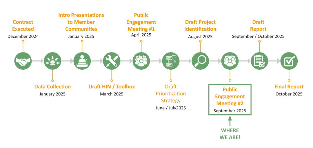
Project Schedule
What is a High-Injury Network?
High Injury Network (HIN)
A data-driven map showing road segments and intersections with the highest concentrations of fatal and serious injury crashes.
- HIN is not an assessment of whether a street or intersection is dangerous.
- The HIN map shows where serious crashes occur most often, helping us identify areas that may need safety improvements.
It reflects REACTIVE analysis based on crashes that have already occurred
High-Injury Network Maps
What is a High-Risk Network?
High-Risk Network (HRN)
The following maps show segments where serious crashes are more likely to happen, even if they haven’t yet.
It helps us improve safety before crashes occur by looking at:
- Functional Classification
- Number of lanes
- Speed limits
- Traffic signs and signals
- Traffic volume and congestion
These areas may not have a crash history, but they show signs of higher risk.
This PROACTIVE approach helps identify areas that may need safety improvements to prevent future crashes.
High-Risk Network Maps
Safety Countermeasures
The document below is a list of proposed safety countermeasures developed as part of the Corridor Connect: A Safe Path Forward. Aligned with FHWA’s Safe System Approach and the SS4A framework, these measures are designed to proactively reduce roadway fatalities and serious injuries. Each countermeasure was selected through a data-driven analysis of the High Injury and High-Risk Networks, ensuring targeted, context-sensitive improvements for all road users.
Potential Safety Projects
To identify and prioritize safety improvement projects throughout the region, a prioritization process was developed that looked at the following components:
- Presence on HIN
- Presence on HRN
- Proximity to Schools, Parks, Transit Routes, Existing Trails
- Overlap with CIP Projects and Future Trails
- Overlap with Areas of Persistent Poverty (APP) and Underserved Communities
- Overlap with PIM Unsafe Locations and Near Misses
For each of these components, a facility satisfied, points were awarded; prioritization scores for the 409 roadway segments and 1,995 intersections were tabulated, and each facility was classified as Low, Mid, and High Tier Priority Projects. Mid-Tier facilities must’ve had prioritization scores of at least 33 points (out of 100), and facilities with prioritization scores of higher than 50 points were classified as High-Tier Facilities. Click the link below to access the Safety Projects Map Survey, where you can explore the Mid- and High-Tier project locations.
Contact Us
Please contact Corridor MPO at corridormpo@corridormpo.com
| Name | Corridor MPO |
|---|---|
| Phone | 319-286-5041 |
| In writing | 101 First Street SE Cedar Rapids, IA 52401 Phone: (319) 286-5041 |


